-
 An extended run of hot temperatures and high humidity is forecast to arrive across Central Illinois on Sunday and last through most of the week.
 -
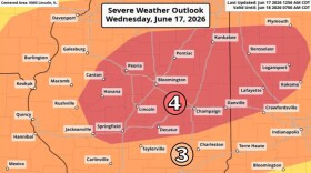 The National Weather Service is preparing for the possibility of two rounds of severe storms on Wednesday, less than one week after nine confirmed tornadoes tore through the region.
 -
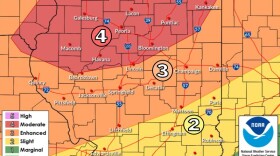 Peoria, Tazewell and Woodford counties are facing an enhanced risk of severe weather (Level 3/4 out of 5) for a storm expected to hit between 5 p.m. to midnight Thursday.
 -
 The National Weather Service has issued a severe thunderstorm watch until 11 p.m. that includes Peoria, Tazewell and Woodford counties.
 -
 Bloomington-Normal and Greater Peoria again avoided the worst of a spring storm system that moved through the area Sunday. A winter weather advisory remains in effect until 1 p.m. Monday.
 -
 The National Weather Service is warning of an enhanced risk of tornados and other severe weather on Tuesday night into Wednesday morning throughout Central Illinois.
 -
 The National Weather Service has issued a Winter Weather Advisory for McLean, Mason, Peoria, Tazewell, Woodford, Fulton and Schuyler counties from 9 a.m. Saturday until midnight Sunday night.
 -
 All Peoria Public Schools will be closed Friday, in response to the extreme cold forecast for the region. The Bradley University campus will also be closed, with classes shifted to remote learning.
 -
 The warning is in effect from 3 a.m. to noon Friday for McLean, Woodford, Tazewell, Peoria, Marshall, Stark and Knox counties.
 -
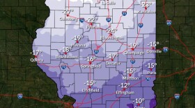 Much of Central Illinois will be facing some extreme cold Thursday night into Friday. Dangerously cold wind chills as low as 25 to 30 degrees below zero are possible.
© 2026 Peoria Public Radio
A joint service of Bradley University and Illinois State University
Play Live Radio
Next Up:
0:00
0:00
Available On Air Stations


